
Preserving the Past with High-Precision Drone Technology and 3D Mapping
- May 20, 2026
- Posted by: admin
- Category: Uncategorized
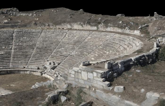
The preservation of historical sites, from ancient buildings and monuments to archaeological sites, is an important task that ensures future generations can appreciate and learn from them. However, documenting these sites without causing any damage can be challenging.
Thanks to advancements in technology, it’s now possible to capture the most intricate details of heritage sites with millimetre-level accuracy, without even having to set foot on-site. State-of-the-art equipment, like drones equipped with high-resolution cameras, makes it possible to explore historic sites and create photorealistic 3D models.
At SurveyHands, we’re proud to introduce the DJI Matrice 4 Enterprise to our fleet, a powerful tool that is currently one of the best in the industry. This advanced technology helps us preserve the past using high-precision photogrammetry techniques, ensuring every detail is captured for future reference, study, and restoration.
What is Photogrammetry and Why is it Important?
Photogrammetry is a technique that uses 2D images to create 3D reconstructions of a physical space. By capturing photographs from multiple angles, photogrammetry software can stitch them together to produce highly accurate and visually realistic models, as well as other outputs such as digital elevation models, surface models, and as-built maps.
When used for historical documentation, photogrammetry offers a unique advantage. It allows digital models to be created for heritage sites without causing any disruption. Drone surveying is completely non-invasive, and it enables these sites to be captured in detail while preserving their authenticity. This is particularly valuable for projects where even small disturbances can have lasting consequences.
The digital models created can then be used for everything from planning restorations to simply preserving the site’s history for future generations.
How the DJI Matrice 4 Enterprise Enhances Our 3D Mapping Services
While photogrammetry itself is an incredibly powerful method for preservation, the DJI Matrice 4 Enterprise takes our 3D mapping capabilities to new levels. This professional-grade drone is equipped with advanced features that enable us to capture the finest details of heritage sites with unmatched accuracy. Whether it’s the intricate carvings on a monument or the original architectural details of a historic building, we ensure nothing is missed.
Not to mention, using a drone allows us to access areas that are difficult or even dangerous to reach physically. We collect the data from the safety of the ground, enabling us to document even the most fragile or high-risk sites without the need for intrusive scaffolding or other hazardous methods.
In addition to its imaging capabilities, the DJI Matrice 4 Enterprise also makes data collection much more efficient. Traditional surveying methods can be time-consuming, especially when dealing with complex or large areas. This drone allows us to cover historic sites quickly and accurately, reducing the time spent on data capture and delivering faster results. We can begin creating the 3D models straight away, which is key for time-sensitive documentation projects.
The Benefits of 3D Mapping for Historical Documentation
3D mapping is undeniably beneficial for historical documentation. With drones like the DJI Matrice 4 Enterprise, we can produce incredibly detailed digital models of heritage sites, offering several benefits for preservation, restoration, and education.
- Non-invasive preservation – One of the biggest advantages of drone photogrammetry services is that you don’t have to physically access the historic sites. Unlike traditional methods, which often require physical measurements or even alterations to the site, drones capture data from the air, ensuring the site isn’t disturbed in any way.
- Accurate restoration planning – When restoration is required, a detailed 3D model is invaluable. You will have a digital version of the site, which can guide restoration efforts and help ensure that any changes are made in line with the original structure. The precision of drone technology means the data capture is highly accurate, making future projects more true to the original design.
- Public access and education – Once the data is captured, any 3D models or other outputs can be shared digitally, allowing people all around the world to explore and learn about these historic locations. Whether it’s interactive models or virtual tours, you can increase public awareness of certain sites and the importance of preserving them, creating a deeper understanding of cultural heritage.
- Ongoing monitoring – The ability to regularly capture up-to-date data allows for ongoing monitoring of heritage sites. Over time, new 3D models can be compared with the previous ones, enabling you to detect any changes or signs of deterioration. This is particularly useful for identifying subtle damage that may not be visible to the naked eye, allowing for proactive conservation efforts.
How Drone Technology is Changing Heritage Site Preservation
The integration of the DJI Matrice 4 Enterprise into our 3D photogrammetry services has transformed the way we document and preserve heritage sites. This technology allows us to capture the intricate details of historic buildings, monuments, and archaeological sites with unparalleled precision to create non-invasive digital records that can be updated over time. Here’s why drone technology is essential for historical documentation:
- Accuracy – Traditional methods often rely on manual measurements and sketches, which are prone to human error. With drones, we capture high-resolution images to create digital models that are far more accurate than ever before. This level of precision is essential for ensuring that heritage sites are preserved exactly as they are.
- Preservation of detail – Drones can document the finest details of a site, from intricate carvings to structural features that might otherwise be overlooked. The ability to digitally preserve these features ensures that future generations will have access to every detail of these historically significant sites, no matter how small.
- Reduced costs – Traditional surveying methods often require scaffolding, cranes, and other expensive equipment. By using drones, we eliminate many of these costs and reduce the time needed for documentation. The speed and efficiency of drones allow us to capture data in a fraction of the time, ultimately making it a cost-effective solution.
The Future of Historical Documentation
Adding the DJI Matrice 4 Enterprise to our fleet marks a major step forward in the field of historical documentation. By combining high-precision drone technology with 3D mapping, we can now offer a service that is more accurate and efficient than ever before. This technology allows us to document and preserve heritage sites in ways previously impossible, ensuring they are protected for future generations to appreciate.
Whether you’re a historian, archaeologist, or owner of a historic site, photogrammetry services offer one of the safest methods for documenting every detail. If you’re interested in historical preservation or documentation, please reach out to our team to learn how we can help you using the latest drone technology.