Large-Scale Drone Mapping: Fast, Accurate and Cost-Effective Surveying for Expansive Areas
- May 11, 2026
- Posted by: admin
- Category: Uncategorized
Surveying large sites, whether for mining, agricultural, or construction purposes, requires both precision and efficiency. Traditional methods can be time-consuming, costly, and sometimes even hazardous, especially when working in remote or difficult-to-reach locations.
That’s why we use advanced drone technology and mapping software at Surveyhand Engineering, such as the DJI Matrice 4 Enterprise, enabling us to handle a wide range of advanced processes in-house. With this cutting-edge technology, we can gather highly detailed data in a fraction of the time it would take with conventional methods, enabling faster decision-making and improved project planning. This is especially valuable when dealing with expansive areas that need precise measurements and regular monitoring.
By using drones for large-scale mapping, we offer a service that goes beyond simple data collection. It’s about providing a seamless experience that supports tight deadlines, reduces costs, and improves project outcomes.
The Importance of Large-Scale Mapping
When managing a large site, accurate and up-to-date mapping is essential for a variety of reasons. Precise data enables you to make better decisions about design, resource allocation, and safety. Here’s how large-scale mapping plays a key role:
- Assess site conditions and terrain: Understanding the layout and features of your site early on helps you plan construction, farming, or mining operations with confidence.
- Ensure regulatory compliance: Accurate data ensures your project meets environmental and zoning regulations, especially for large-scale developments or sensitive areas.
- Track project progress over time: Having a digital record allows you to compare current site conditions with past data to measure changes.
- Enhance collaboration: By working from a single data source, project teams across disciplines can stay aligned and make decisions faster.
Traditionally, surveying large sites involves manual ground measurements and multiple site visits, which are not only time-consuming but can also be error-prone. Drone technology, however, enables us to capture large areas with high precision, speeding up the process while delivering reliable and actionable data.
Applications of Large-Scale Mapping in Projects
Large-scale mapping can be applied across various sectors to support improved operational efficiency. Here’s a closer look at some of the industries that can benefit:
Mining – Monitor Land Stability and Ensure Compliance
In mining, regular and precise mapping is essential. With drone technology, we can help monitor land stability, calculate stockpile volumes, and ensure your site complies with environmental regulations. Using 3D models, we can:
- Track land movement to identify subsidence or erosion risks early, helping mitigate safety hazards.
- Accurately measure stockpiles to reduce discrepancies in volume calculations, streamlining operations and improving inventory management.
- Monitor reclamation progress to support the future use of the land, whether for agriculture, forestry, or recreational areas, ensuring compliance.
Agriculture – Improve Crop Management and Land Planning
Agricultural land requires constant monitoring for optimal use and crop management. Our large-scale mapping services give you detailed aerial maps that assist with:
- Identifying problem areas to detect soil erosion, irrigation needs, or other issues that could affect crop yield.
- Designing more effective irrigation systems that reduce water wastage and ensure overall better crop health.
- Tracking field conditions to assess the land’s health and make more informed decisions about where to plant, irrigate, or harvest.
Construction – Support Design, Planning, and Monitoring
For large-scale construction projects, having accurate data is key for everything from site preparation to ongoing management. Our drone surveying helps:
- Provide architects and engineers with highly detailed 3D models of your site to ensure site plans and designs are based on real-world conditions.
- Accurately measure earthworks and stockpiles, helping to optimise material usage, reducing costs and waste.
- Track construction progress by comparing new data against previous models, enabling quick identification of discrepancies or delays to project timelines.
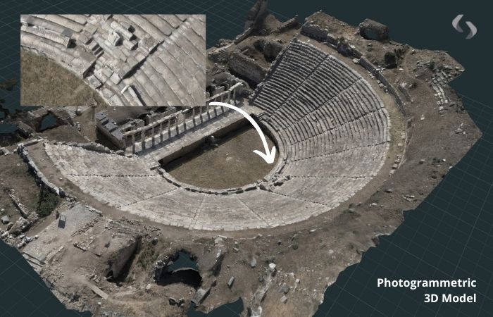
The Process of Large-Scale Mapping
At Surveyhands Engineering, we use the latest drone technology and photogrammetry to create detailed, photorealistic 3D models of real-world spaces. With our DJI Matrice 4 Enterprise drone, we efficiently capture high-resolution imagery, enabling us to work on large-scale projects without compromising accuracy. Here’s how we approach large-scale mapping to ensure it aligns perfectly with your project needs:
Initial Planning and Site Assessment
Every successful mapping project begins with careful planning. Before we deploy equipment, we focus on understanding your project’s specific requirements. This might include a mining site, an agricultural area, or a construction zone. Key aspects we cover include:
- The purpose of the survey
- Desired deliverables, from 3D models to elevation maps
- Access considerations and site logistics
This initial consultation enables us to tailor our flight path, equipment setup, and data capture methods specifically to your needs. It also helps us manage all the safety protocols and permissions required to fly drones in your area.
Comprehensive Data Collection
Once we have our plan in place, we deploy the DJI Matrice 4 Enterprise drone. The advanced sensors and high-resolution cameras capture accurate images from multiple angles, which are then processed using photogrammetry software.
Compared to traditional survey methods, the drone allows us to cover large areas in a fraction of the time, reducing disruption to ongoing operations and ensuring faster data collection. Whether you need comprehensive mapping over several acres or detailed scans of specific areas, our drone technology delivers real-time data you can trust.
Processing and Delivering Results
After collecting the data, our team processes it into detailed outputs. The deliverables we provide vary depending on your project’s scope and needs, but typically include:
- 2D outputs, including digital elevation models, digital surface models, orthomosaics and as-built maps of your space.
- Detailed 3D reconstruction of your space.
- Professional video content, including aerial-style views that show the full layout and close-ups of specific areas.
The processed data is delivered in a variety of formats that integrate seamlessly with industry-standard software such as AutoCAD, Nubigon, and Autodesk Revit, so you can get started on your project immediately.
Key Benefits of Large-Scale Mapping with Surveyhands
Regardless of the purpose of the survey or your desired deliverables, choosing drone-based large-scale mapping with Surveyhands Engineering will provide tangible value to your project.
Speed and Efficiency
In traditional surveying, covering large areas can take days or weeks. By using drones, we can collect vast amounts of data in just a few hours, significantly speeding up the entire surveying process. This efficiency is especially useful when you’re working with tight timelines or need to update data periodically for ongoing monitoring.
Cost Savings
The efficiency of drone mapping doesn’t just save time; it also reduces costs. Traditional methods require substantial manpower and equipment, which can quickly increase project costs. By reducing manual data collection and site visits, we offer a more affordable solution for large-area surveys without sacrificing accuracy.
Higher Accuracy and Detail
The DJI Matrice 4 Enterprise drone delivers precision down to the millimetre, capturing highly accurate data that’s essential for site planning and design. This accuracy ensures that the models and maps are reliable, reducing the likelihood of discrepancies that could lead to future issues. Detailed data is non-negotiable, especially in industries where small errors can have significant consequences.
Reduced Site Visits and Increased Safety
One of the most significant advantages of using drone mapping is that it minimises the need for site visits. By capturing all necessary data from the air, we eliminate the risks of sending personnel into potentially hazardous environments, such as remote mining sites or infrastructure projects. The DJI Matrice 4 Enterprise allows us to gather data safely and efficiently, keeping your team safe and reducing downtime.
Want to Find Out More About Large-Scale Mapping?
If you’re looking for a faster, more cost-effective way to map large sites, Surveyhands Engineering is here to help. Our experienced team uses advanced drone technology to deliver high-quality results that meet your project’s needs.
Whether you’re working on a mining operation, agricultural land, or a large construction project, our large-scale mapping services will provide you with the data you need to make informed decisions and keep your project on track.
Get in touch with us today to learn more about how our 3D mapping services can help your project succeed.